NYC Summer Streets 2026 Route for Runners and Cyclists
Where the Summer Streets 2026 Manhattan route runs, segment by segment: distances, elevation shifts, and the workout each stretch suits, from Brooklyn Bridge to Dyckman Street — plus the shorter outer-borough routes as alternatives.
- Equipment tier required
- none
- Duration
- varies min
- Difficulty
- intermediate
- Target area
- legs
For the nyc summer streets 2026 running cycling route, start with the official map logic, not the mileage folklore: NYC DOT’s Manhattan corridor runs from the Brooklyn Bridge up to Dyckman Street, with activity and rest-stop locations along the way at Foley Square, Astor Place, Rose Hill, Grand Lawn, Midtown, East Harlem, Adam Clayton Powell Jr. Blvd, 125th & Broadway, 159th & Broadway, Plaza de las Americas, and Dyckman & Broadway.[1]
That is the useful fact before dawn. The corridor is long enough to become a real workout, but it does not behave like one uniform route. The lower miles let you lock into pace. Midtown breaks the rhythm. The northern end, especially once the route works through Broadway above 110th Street, asks for a different set of legs.
The official corridor, in workout terms
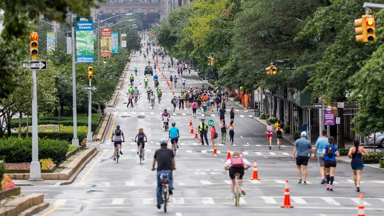
Summer Streets is the city’s recurring car-free street program, with selected corridors opened to people walking, running, biking, skating, and using the roadway without regular vehicle traffic.[2] For 2026, NYC DOT frames the program citywide as “more than 20 miles” of car-free streets, rather than publishing one clean Manhattan-only, one-way distance.[1]
That distinction matters. You will see Manhattan described as roughly 13 to 14 miles one-way, and adjacent community coverage has put one longer version of the route context at 14.8 miles.[3] Treat that as a planning range, not a certified course. If you are trying to hit exact marathon-pace volume, use your watch. If you are choosing the kind of session this route can support, the segments matter more than the total.
| Manhattan segment | Practical use | What to expect |
|---|---|---|
| Brooklyn Bridge / Foley Square through lower Park Avenue | Controlled tempo, steady aerobic running, easy recovery spinning | Flatter rhythm, more room to settle before the route gets busier and more varied |
| Midtown Park Avenue and viaduct stretch | Mixed-effort running, form checks, relaxed cycling with attention | Changes in grade, surface feel, crowding, and line choice |
| Broadway above W 110th Street toward Dyckman | Hill work, strength running, lower-cadence cycling efforts | Sustained climbing pattern rather than the flatter feel of the lower route |
Lower Park Avenue is where the route gives you pace
If the plan is a tempo run, progression run, or easy endurance ride, the southern half is the part to respect. From the Brooklyn Bridge / Foley Square area into lower and midtown Park Avenue, the route is the closest thing Summer Streets gives you to a predictable training lane: long blocks, familiar sightlines, fewer sustained climbs, and enough continuity to find cadence before the crowds and intersections start making decisions for you.
For runners, this is the place to warm up gently, then settle. A practical version is simple: start easy through the lower blocks, let the watch calm down, then use the Park Avenue rhythm for controlled work rather than surging every time the street opens up. Cyclists get the same benefit, especially if the goal is a steady aerobic spin instead of a stop-start photo ride.
The rest stops also make this lower section forgiving. Foley Square, Astor Place, Rose Hill, Grand Lawn, and Midtown give you several places to regroup before the northern half starts asking more from the route choice.[1] If you are running with someone at a different pace, this is where meeting points are easiest to explain without turning the workout into a scavenger hunt.
Midtown is useful, but it is not where I would chase perfect splits
The midtown stretch is the part of the Manhattan Summer Streets route that looks great in photos and feels less tidy on a watch file. Park Avenue’s viaduct section changes the workout because the roadway, grade, and crowd behavior stop feeling like the lower avenue. That is not a problem. It just means this is better used for movement quality and relaxed effort than for proving fitness.
On foot, shorten the ambition here. Keep the effort honest, but do not overreact to pace noise if you are weaving, climbing, descending, or easing around families and slower bikes. On a bike, hold your line and give yourself more braking room than you think you need. Car-free does not mean obstacle-free; it means the obstacles are people, scooters, kids, dogs, and other riders doing their own version of the morning.
This is also where a route guide should stop pretending that the whole corridor has one personality. If you want clean, metronomic work, get most of it done before the route’s middle starts changing texture. If you want a social spin or a medium-long run that feels like New York rather than a treadmill belt, keep going.

Above 110th Street, the route becomes a hill session
The northern section is where the Manhattan corridor stops being just a long open street and starts becoming strength work. The route context above W 110th Street has been covered by West Side Rag in connection with the extended uptown Summer Streets alignment, including the Broadway stretch toward Dyckman.[3] NYC DOT’s official 2026 materials place rest stops at Adam Clayton Powell Jr. Blvd, 125th & Broadway, 159th & Broadway, Plaza de las Americas, and Dyckman & Broadway.[1]
This is where the community elevation logs become useful. A Strava-linked 2024 route log published at run.dblock.org shows the largest per-mile climbs later in the route, including roughly +99 feet around mile 9 and +46.6 feet around mile 12.[4] Community discussion has also described the full Manhattan effort as roughly 500 feet of total gain, though that should be treated as a community-reported estimate rather than a verified course measurement.
In plain training language: do not spend the whole lower route pretending the northern route will feel flat. If you run northbound, the Broadway portion is a good place for steady hill effort, controlled threshold climbing, or a long-run finish that builds strength without needing repeats. If you ride it, expect cadence to drop unless you deliberately keep the gear light. The climb is not alpine; it is New York annoying, which is sometimes more useful.
The cleanest way to use it is to decide before you start whether the hill is the workout or just the way home. If it is the workout, stay conservative downtown and let the climbing miles carry the quality. If it is not the workout, cut the route earlier or treat everything north of 110th as aerobic strength, not pace work.
A small route-note annoyance: Adam Clayton Powell Jr. Blvd
There is a minor discrepancy in secondary route listings: TimeOut described the Adam Clayton Powell Jr. Blvd segment as W 110th to W 125th, while NYC DOT’s official Summer Streets page lists Adam Clayton Powell Jr. Blvd from W 110th to W 113th.[1] Use the DOT version when planning, especially if you are giving directions to someone meeting you mid-route.
How to choose your start and stop
The full Brooklyn Bridge-to-Dyckman idea is tempting, but the better move is to match the start to the workout. A runner doing quality work does not need to prove anything by dragging tired form into the climb. A cyclist looking for a relaxed car-free morning may not want the northern grade to become the whole story.
| Workout goal | Best Manhattan route choice | Pacing note |
|---|---|---|
| Tempo run | Start downtown and use the lower Park Avenue rhythm | Keep the quality before the route becomes more variable |
| Easy long run | Use the corridor in sections, with rest stops as regroup points | Let pace float in midtown and uptown rather than forcing even splits |
| Hill-strength run | Save the work for Broadway above W 110th Street | Arrive controlled, then climb by effort |
| Recovery ride | Stay lower or mid-route unless you want climbing | Use light gearing and avoid treating every open block as a sprint |
| Car-free sightseeing spin | Ride as much of the corridor as time and crowds allow | Prioritize line choice, patience, and predictable braking |
For hydration and shoes, plan like the route is longer than your mood at the start. The rest stops help, but they do not replace showing up with a bottle strategy, a shoe you already trust, and enough patience to slow down where the street gets crowded. If weather, recovery, or schedule kills the outdoor plan, this is the kind of day where an indoor bike training plan, quiet indoor cycling workout, or beginner cardio training plan is a better fallback than forcing bad miles into a crowded corridor.
Shorter Summer Streets routes if Manhattan is too much
The outer-borough routes are not consolation prizes. They are the better call when you want the car-free street experience without committing to the Manhattan distance, the uptown climb, or the logistics of getting home from Dyckman.
| Borough | Official 2026 corridor | Approximate length / best use |
|---|---|---|
| Queens | Vernon Blvd | Shorter car-free riding or relaxed running when you want a waterfront-side feel without the Manhattan commitment |
| Staten Island | Broadway | A shorter local option for easy miles, family riding, or a low-pressure spin |
| Brooklyn | Eastern Parkway | Good for steady movement on a broad corridor, especially if Manhattan logistics are the barrier |
| Bronx | Grand Concourse | Useful for a shorter urban corridor workout with less need to build the day around the full Manhattan line |
NYC DOT lists the 2026 outer-borough corridors as Queens on Vernon Blvd, Staten Island on Broadway, Brooklyn on Eastern Parkway, and the Bronx on Grand Concourse.[1] Since DOT’s public framing is citywide mileage rather than a neat official distance for each runner’s exact path, keep these as approximate planning options unless you map your own start and stop.
Race-world and bike-share notes that are actually useful
NYRR’s 2026 Start Line Series ties into the Summer Streets season, which is worth knowing if you like a more organized running prompt or want to pair the open-street morning with a race-adjacent event.[5] It should not change how you pace the corridor unless you are specifically entering one of those events.
For cyclists who do not want to bring a bike, NYC DOT’s July 10, 2026 announcement listed Citi Bike promotional codes SUMMER2WHEEL for July 25 and LYFT2WHEELS26 for August 1.[6] Codes for August 8, 15, and 22 were not confirmed in the research materials beyond DOT’s note that Lyft would release additional information through social channels, so do not plan a ride around last year’s code or an assumed 2026 repeat.
Read the Manhattan route in pieces, not as a medal
The Manhattan Summer Streets corridor is most valuable when you stop treating Brooklyn Bridge to Dyckman as one heroic line. The lower Park Avenue miles are where to run or ride with control. Midtown is where to accept variation and keep moving well. Broadway above 110th Street is where the day turns into strength work.
If that map fits your morning, take the full route or build a point-to-point around it. If it does not, use Queens, Staten Island, Brooklyn, or the Bronx for a shorter car-free session and save Manhattan for a day when the segment you want matches the legs you have.
References
- Summer Streets — NYC Department of Transportation.
- Summer Streets — Wikipedia.
- Summer Streets Returns Uptown This Saturday, With 14.8-Mile Route From Brooklyn Bridge to Inwood — West Side Rag, 2025.
- Summer Streets — run.dblock.org, 2024.
- NYRR Start Line Series — New York Road Runners, July 13, 2026.
- Mayor Adams, NYC DOT Announce 2026 Summer Streets — NYC Department of Transportation, July 10, 2026.
What a small equipment investment adds
We don't have a build tagged to this exact tier yet. Browse all builds.
How often should you repeat this?
See our recovery and rest reference for citation-anchored rest-interval guidance.
Spot something off?
Tell us if a movement, tier assumption, or duration didn't match your experience.